Showing 681 items matching roof garden
-
 Stawell Historical Society Inc
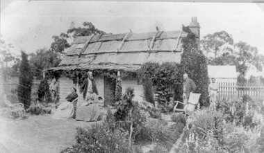
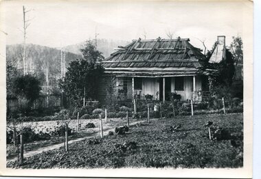
Photograph, Weatherboard Cottage with Bark Roof and garden c1880
... Weatherboard Cottage with Bark Roof and garden c1880...Weatherboard Cottage with Bark Roof and garden c1880... grampians Photograph Weatherboard Cottage with Bark Roof and garden ...Weatherboard Cottage with Bark Roof and garden c1880stawell house -
 University of Melbourne, Burnley Campus Archives
Work on paper (item) - Garden Design, Hassel, Visualisation 02
... roof garden...A preliminary design for the roof garden on top... Visualisation 02 A preliminary design for the roof garden on top ...It is called 'Visualisation 2' so was likely part of a set. burnley horticultural college, roof garden, garden design -
 University of Melbourne, Burnley Campus Archives
Album - Digitised, Joanne Morris, Class of 1973 Reunion and Garden Views, 2014
... the roof garden... for MIFGS 2014, Container Roof and Vertical Garden. (15) The Roof... for MIFGS 2014, Container Roof and Vertical Garden. (15) The Roof ...Digitised photographs of Gardens taken for Class of 1973 Reunion in June 2014 donated by former student, Joanne Morris in June 2014. (1, 2) Garden beds around new entrance gates to Field Station. (3) Brachychitron rupestris, Queensland Bottle Tree, Rainforest Native Garden (commenced 1992). (4) Joanne Morris and Jill McDonald at the Reunion Dinner. (5) Peter Bolch as a student. (6) Plaque commemorating new gates at entrance to Field Station. (8) Plaque on fountain in the Herb Garden commemorating Enid Carberry, an early student (see B13.0002). (9)New garden beds around Sugar Gum table setting. (10) Plaque on the Sugar Gum table setting dedicated to Geoff Olive. (11) New garden beds around entrance to Field Station. (12) Sugar Gum table setting. (13) Plaque describing the Luffmann Ponds. (14) Entry for MIFGS 2014, Container Roof and Vertical Garden. (15) The Roof Garden. (16) Centennial Centre, former Dairy. Also see B14.0078 Reunion.gardens, class 1973, class reunion, students, joanne morris, garden beds, field station, brachychitron rupestris, queensland bottle tree, rainforest native garden, jill mcdonald, reunion dinner, peter bolch, herb garden, enid carberry, sugar gum, geoff olive, luffmann ponds, container roof, vertical garden, the roof garden, centennial centre, dairy, plaques -
 University of Melbourne, Burnley Campus Archives
Photograph - Colour and black and white photocopy, Kneen and Macauley Visit to Burnley Gardens, 1969-2013
... roof garden...). (3) Cam, Dawn and Celia Kneen on the Roof Garden. (4) Cam...) Cam, Dawn and Celia Kneen on the Roof Garden. (4) Cam, Dawn ...0n 25 April 2013 when some members of the Kneen and Macauley families visited Burnley Gardens for afternoon tea organised by the FOBG.Print outs from mail attachment of photographs taken 0n 25 April 2013 when some members of the Kneen and Macauley families visited Burnley Gardens for afternoon tea organised by the FOBG. (1) Macauleys and Kneens with Andrew Smith in front of the Centenial Building (Dairy). L-R Averil's husband, Averil Macauley, Andrew Smith, Barry Macauley, Douglas Kneen (Tom's brother, designed the Burnley Logo), Celia Kneen, Cam Kneen, Dawn Kneen. (2) Averil's husband, Averil Macauley, Andrew Smith, Barry Macauley, Douglas Kneen. Standing in front of the Centenial Building (Dairy). (3) Cam, Dawn and Celia Kneen on the Roof Garden. (4) Cam, Dawn and Celia Kneen, Averil Macauley on the Roof Garden. Photocopies of photographs sent to the Archives by Jan Downman (nee Macauley) August 2013 Dated 1976 (5a) Garden view. (5b) Luffmann Ponds. (5c) Principal's Residence. (5d) Luffmann Ponds, Cork Oak. (6a) Principal's Residence. (6b) Looking towards Swan Street, Plant Research Institute. (6c) Administration Building. (7a) "Burnley Gardens 1971 Melva Macauley with granddaughter Rebecca Macauley (2 yrs). (7b) C "Burnley Horticultural College 1969 Rebecca Macauley (Jennifer behind).burnley gardens, fobg, andrew smith, centenial building, dairy, averil macauley, barry macauley, douglas kneen, celia kneen, cam kneen, dawn kneen, roof garden, jan downman (nee macauley), garden views, luffmann ponds, principal's residence, cork oak, plant research institute, melva macauley, rebecca macaule, burnley horticultural college -
 University of Melbourne, Burnley Campus Archives
Album - Digitised, Joanne Morris, Visit to Burnley April 2014, 2014
... roof garden... the Hall. (40,41) Roof Garden. (42,43) Library. (44-50) Views... the Hall. (40,41) Roof Garden. (42,43) Library. (44-50) Views ...Collection of digitised photographs taken in preparation for the Class of 1973 Reunion in 2014. Garden views and buildings. Donated by Joanne Morris, former student, in June 2014. See Digitised photos- Garden Views folder- Visit to Burnley April 2014. (1) Luffmann Ponds. (2) Administration Building. (3) Emily Gibson Beds and Ginkgo biloba. (4) Looking towards Native Garden. (5) Oak tree. (6) Looking towards Rose Garden. (7) Looking towards Stream Garden and Fern Garden. (8) Looking towards Rose Garden. (9) Plaque at entrance to Field Station. (10) New gates at entrance to Field Station donated by the Friends of Burnley Gardens. (11, 12) Field Station. (13) Plaque in Herb Garden commemorating Enid Carberry. (14) Fountain in Herb Garden commemorating Enid Carberry. (15) Forestry Building. (16-18) Inside Forestry Building. (19) Sugar Gum Table Setting donated by the Friends of Burnley Gardens. (20) Plaque on Sugar Gum Table commemorating Geoff Olive. (21, 22) View of Luffmann Ponds and Summer House. (23) Plaque at Luffmann Ponds. (24) Luffmann Ponds. (25) View of former Egg-Curator's Residence from Nursery. (26) Back of Nursery. (27,28) The Burnley entry for the Melbourne International Flower and Garden Show 2014. (29) Back of Administration Building. (30) Plant Science Laboratories. (31) Student Amenities Building. (32-34) Plant Science Laboratories. (35) Citriodora Court. (36) Eucalyptus maculata at entrance to Native Garden. (37) Native Garden, James Hitchmough Grasslands. (38) Garden view. (39) Inside the Hall. (40,41) Roof Garden. (42,43) Library. (44-50) Views of the Quad and classrooms. (51) Dairy. (52) Building 904,(Centre for Urban Horticulture) now Waterway Ecosystem Research Group. (53) Yarra Boulevard entrance.class 1973, class reunion, garden views, buildings, joanne morris, students, luffmann ponds, administration building, emily gibson beds, ginkgo biloba, native garden, oak tree, rose garden, stream garden, fern garden, field station, friends of burnley gardens, plaques, herb garden, enid carberry, fountain, forestry building, sugar gum table, geoff olive, summer house, egg-curator, residence, nursery, melbourne international flower and garden show, 2014, plant science laboratories, student amenities building, citriodora court, eucalyptus, james hitchmough grasslands, roof garden, library, quad, classrooms, dairy, centre for urban horticulture, waterway ecosystem research group, yarra boulevard entrance -
 Glen Eira Historical Society
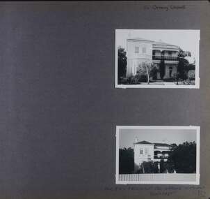
Album - Album page, 84 Orrong Crescent, Circa 1972
... hart verandah porch slate roof garden decorative brackets ...This photograph is part of the Caulfield Historical Album 1972. This album was created in approximately 1972 as part of a project by the Caulfield Historical Society to assist in identifying buildings worthy of preservation. The album is related to a Survey the Caulfield Historical Society developed in collaboration with the National Trust of Australia (Victoria) and Caulfield City Council to identify historic buildings within the City of Caulfield that warranted the protection of a National Trust Classification. Principal photographer thought to be Trevor Hart, member of Caulfield Historical Society. Most photographs were taken between 1966-1972 with a small number of photographs being older and from unknown sources. All photographs are black and white except where stated, with 386 photographs over 198 pages. From Victorian Heritage Database citation for 84 Orrong Crescent https://vhd.heritagecouncil.vic.gov.au/places/35584 as at (28/10/2020) "St. Reliers" at 84 Orrong Crescent is important as an unusually excessively enriched asymmetrical villa residence of the Boom period. From Victorian Heritage Database citation for HO50 84 Orrong Crescent Caulfield North https://vhd.heritagecouncil.vic.gov.au/places/35584 as at (28/10/2020) An imposing Italianate two storeyed asymmetrical villa with overpainted stuccoed surfaces to the facade, distinguished by their ornate treatment. Unusually rich ornamentation includes the acanthus leaf impost capitals, aedicules with swags and volutes, foliated panels to the frieze, ashlar treatment to the lower level and quoins above. The two storeyed cast iron verandah with timber frieze rail protects a black and white tiled floor. The hipped roof has patterned slates.Page 152 of Photograph Album with two landscape photographs of Bonhurst on Orrong Crescent.Handwritten: 84 Orrong Crescent [top right] / NOW 84 - PREVIOUSLY 120 ORRONG CRESCENT / "BONHURST" [under bottom photo] / 152 [bottom right]trevor hart, verandah, porch, slate roof, garden, decorative brackets, fanlight, protruding bay, bay window, garden lamp, asymmetrical, bonhurst, st reliers, rendered, orrong crescent, caulfield north, cast iron work, victorian style, mansions, house names, slate roofs, italianate style -
 Glen Eira Historical Society
Album - Album page, Grimwade House, Orrong Road, Circa 1972
... in 1911. trevor hart verandah porch slate roof garden grimwade ...This photograph is part of the Caulfield Historical Album 1972. This album was created in approximately 1972 as part of a project by the Caulfield Historical Society to assist in identifying buildings worthy of preservation. The album is related to a Survey the Caulfield Historical Society developed in collaboration with the National Trust of Australia (Victoria) and Caulfield City Council to identify historic buildings within the City of Caulfield that warranted the protection of a National Trust Classification. Principal photographer thought to be Trevor Hart, member of Caulfield Historical Society. Most photographs were taken between 1966-1972 with a small number of photographs being older and from unknown sources. All photographs are black and white except where stated, with 386 photographs over 198 pages. From Victorian Heritage Database citation HO54 Grimwade House, former Harleston stables, outbuilding, garden, gate and Picconia excelsa tree. https://vhd.heritagecouncil.vic.gov.au/places/35573 as at (28/10/2020) ''Harleston'', now "Grimwade House", is situated at no. 67 Balaclava Road, Caulfield North, at the Orrong Road corner. It was built for Frederick, later Sir Frederick, Grimwade, to the design of architect Thomas Watts in 1875. Today the complex has been incorporated in the Melbourne Grammar Junior School campus. It retains not only the main house but also the stables and mature garden setting with driveway and gates. It is historically, aesthetically and socially significant.From Victorian Heritage Database citation HO54 Grimwade House, former Harleston stables, outbuilding, garden, gate and Picconia excelsa tree. https://vhd.heritagecouncil.vic.gov.au/places/35573 as at (28/10/2020) It is historically significant (Criterion A) as the former home of prominent business man, speculator and benefactor, Sir Frederick Grimwade. Both Grimwade and his house are exemplars of the commercial enterprise of the Boom period and the amassing of personal fortunes with which it is associated. It is aesthetically significant (Criterion E) as an imposing yet stately large house of its time, the classic Italian form with comer verandah terminated by projecting wings being most distinctively seen in this instance. It is enhanced not only by the garden setting but also by the delicate cast iron verandah spandrels, stained glass work and stencilled ceiling in the music room. It is socially significant (Criterion G) on account of the value placed on it by the community associated with the Melbourne Grammar Junior School since its inception on this site in 1911.Page 154 of Photograph Album with five photographs (4 landscape and one portrait) including Grimwade House, gates and a tram shelter.Handwritten: Grimwade House (Melbourne Grammar Prep School) / incorporating "Harleston" Orrong Rd. S.E cnr Balaclava Rd [top right] / 154 [bottom right]trevor hart, verandah, porch, slate roof, garden, grimwade house, grimwade, harleston, sir frederick grimwade, thomas watts, orrong road, balaclava road, melbourne grammar, melbourne grammar junior school, italianate, cast iron verandah spandrels, stained glass, stencilled ceiling, mgs, m.g.s, school, grimwade family, jessie grimwade, gates, palisade style fence, cast iron spears, stone plinths, melbourne grammar prep school, victorian style, cast iron work, caulfield north, gardens, cars, tram services, outbuildings, stables, trees, picconia excelsa tree -
 Glen Eira Historical Society
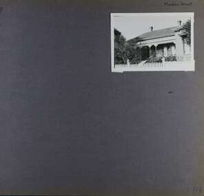
Album - Album page, Meadow Street, Circa 1972
... picket fence slate roof chimneys garden cast iron columns cast ...This photograph is part of the Caulfield Historical Album 1972. This album was created in approximately 1972 as part of a project by the Caulfield Historical Society to assist in identifying buildings worthy of preservation. The album is related to a Survey the Caulfield Historical Society developed in collaboration with the National Trust of Australia (Victoria) and Caulfield City Council to identify historic buildings within the City of Caulfield that warranted the protection of a National Trust Classification. Principal photographer thought to be Trevor Hart, member of Caulfield Historical Society. Most photographs were taken between 1966-1972 with a small number of photographs being older and from unknown sources. All photographs are black and white except where stated, with 386 photographs over 198 pages. Page 134 of Photograph Album with one landscape photograph of a Victorian house on Meadow Street.Handwritten: Meadow Street [top right] / 134 [bottom right]trevor hart, east st kilda, decorative brackets, picket fence, slate roof, chimneys, garden, cast iron columns, cast iron frieze, meadow street, st kilda east, caulfield, victorian style, cast iron work, verandahs -
 Stawell Historical Society Inc
Photograph, Vicarage at 30 Seaby Street for the Anglican Church c1863
... iron roof. Garden in forground. ... with a corrugated iron roof. Garden in forground. Original Vicarage 30 Seaby ...Original Vicarage 30 Seaby Street c1863. Used by the Anglican Church until 1923 when it was sold. This house is one of the oldest in Stawell. It was built in 1863 as the residence of the Church of England Vicar. Separate to the original Vicarage the Christ Church of England was built on the hill opposite in the same year. Many couples were married in the Drawing Room of the vicarage as was the custom at the time. In 1872, 9 years later a new church called Holy Trinity Church of England was built in Main St. Stawell to replace Christ Church which had become too small and too far from the main population. The Vicarage remained until 1922 when the house next door to Holy Trinity Church was purchased as the new Vicar's residence. Black and white photograph of a brick home with cement render. Veranda around three side of the house with a corrugated iron roof. Garden in forground. stawell -
 Sunbury & District Heritage Association Inc
Photograph, Fitzroy Gardens
... with a tiled roof in a garden setting.... photograph of a small brick cottage with a tiled roof in a garden ...Captain Cook's Cottage was dismantled in his village in England and rebuilt in Melbourne's Fitzroy Gardens in the 1930s. Since then it has been an attraction for many visitors although there is little relationship between Captain Cook as he never set foot anywhere in Victoria. The photograph was taken when the children from Bulla Primary School were taken on an excursion to the gardens,A non-digital coloured photograph of a small brick cottage with a tiled roof in a garden setting.school excursions, bulla primary schooil, fitzroy gardens -
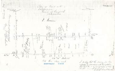 Ringwood and District Historical Society
Document - Copy of Lands Department Field Notes - Parish of Ringwood, Victoria, Field Notes 88-9/276 - Part of O.P. R72C surveyed 12.10.1888
... , Quigley, WB house iron roof, paling & shingle roof, garden..., Quigley, WB house iron roof, paling & shingle roof, garden ...Foolscap size photocopy of survey map with handwritten notations. References include - Commencing at bank of creek, Bearing over fence read 134"12', post and rail fence, old round post, Quigley, WB house iron roof, paling & shingle roof, garden, Forshaw formerly Hoare, D Brown, stable & shed, slats & palings, orchard, Occupied by Forshaw, 4 rooms WB Cottage iron roof, Sherbin, Old three chain road, Maroondah Highway, Molloy's corner, I certify that this survey has been effected in accordance with the regulations and that this is a correct copy of my results (signed) - Reed, Assistant Surveyor, 12.10.88. -
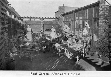 Royal District Nursing Service (now known as Bolton Clarke)
Photograph - Digital Image, c.1935
... (Sisters) supervising convalescing children in the roof garden... (Sisters) supervising convalescing children in the roof garden ...This digital image shows the sun roof on the Melbourne District Nursing Society After-Care Hospital, 45 Victoria Parade, Collingwood. It shows some of the children nursed at the home. Many children were nursed there long term during the Poliomyelitis epidemic in the 1930s. It also shows uniforms worn by nurses and Sisters in the 1930s. The Melbourne District Nursing Society After-Care Home was originally established to provide nurse-managed convalescent care to poor and underprivileged patients who could not look after themselves at home due to illness, or on release from hospital. Opening in 1926 following a public appeal for funds, at a cost of £27,000, the Home included maternity, children’s and adult wards as well as accommodation for Matron, twelve Sisters and four domestic staff. Many children were nursed there, some long term, during the Polio epidemic and the Society employed two School Teachers. The Society now ran two divisions, the After-Care with its own Sisters and nurses and the District division. The Society were the first in Melbourne, in early 1928, to recognize some patients leaving the After-Care, and many at home, needed further social care and they set up ‘Almoners’ from their committee to visit these patients and be intermediaries in getting them social assistance. It was late the following year before the first training of Almoners took place in Melbourne. In 1930 the Society employed a full time kindergarten teacher to visit poor children in their homes. That year the Society were pioneers in opening an Ante-Natal Clinic at the After-Care, setting a high standard with equipment, keeping records and providing leaflets with instructions in how to keep healthy during pregnancy, what complications to look for and what to do when labour commenced. In 1934 the Society were pioneers again when they opened the first Women’s Welfare Clinic, including at the time a very controversial Family Planning Clinic, the first of its kind in Australia which was opened to support women at risk following multiple and difficult pregnancies, giving advice on birth-control. At first the clinic was attended by their own patients, but then accepting patients from public hospitals until their own clinics were opened. . Major extensions in 1934 led to the After-Care 'Home' having a name change to 'Hospital'. A trained Almoner was employed in 1934 but she resigned after twelve months due to the work load. Unable to procure another due to a shortage of trained Almoners, a Social Service Officer was employed at the After-Care who successfully gained better housing from the Housing Commission for families living under unsuitable conditions. Following Government intervention, the After-Care Hospital was separated from the Melbourne District Nursing Society in 1957. The After-care Hospital continued to operate at the same address until 1985 when it became the Melbourne Geriatric Centre. This digital Image shows two nurses and two Trained nurses (Sisters) supervising convalescing children in the roof garden of the Melbourne District Nursing Society After-Care Hospital . The two nurses are with the rear children, one on the left and one on the right. Both are wearing long white aprons over their long sleeved dark grey uniforms, and both are wearing white caps over their dark hair. On the right rear, in front of a row of glass windows, the upper portion of a Sister can be seen wearing a white uniform and white veil. In the right front is another Sister who is wearing glasses and is wearing a white uniform and dark coloured cape. She is wearing a white veil over her short dark hair. There are three boys and four girls resting on cane lounges; some are reading books and one girl is holding a doll. Another boy, who is wearing a dressing gown, is sitting on a cane chair. There is a trellis and a wall of windows on the left of the image and some brick work and a wall of windows on the right hand side behind the Sisters.. Some pots with low and tall plants can be seen.A tiled hip roof of a building can be seen in the rear of the image.mdns, melbourne district nursing society, after- care hospital, nurses uniforms -
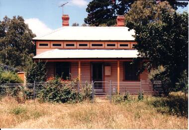 Hume City Civic Collection
Photograph, early 1990s
... corrugated iron roof. The overgrown garden has low growing trees... protruding from the white painted corrugated iron roof. The overgrown ...The weatherboard house is one of the six weatherboard cottages which were built on the east side of O'Shanassy Street in the early 1900s. It has been listed in the Heritage Study in 1998. Scheduled as having some significance and recommended for further investigation.A coloured photograph of a weatherboard Victorian cottage with an overhanging verandah across the double fronted building. The weatherboard walls are painted biscuit and the window and door frames are tan. A wooden tile trim painted in biscuit, tan and dark green. There are two stepped chimneys protruding from the white painted corrugated iron roof. The overgrown garden has low growing trees and shrubs.george evans collection -
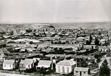 Federation University Historical Collection
Photograph - black and white, Ballarat Looking Towards Black Hill, c1870
... are houses, gardens, shingle roofs, fences, St Patrick's Cathedral... are houses, gardens, shingle roofs, fences, St Patrick's Cathedral ...A black and white photograph, and two details, showing Ballarat from the Ballarat Benevolent Asylum. Evident in the photos are houses, gardens, shingle roofs, fences, St Patrick's Cathedral, Black Hill, Ballarat West Fire Brigade tower, mine dumps, mullock heap, large chimneys.ballarat, ballarat townscape -
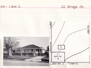 The Beechworth Burke Museum Research Collection
Card (Series) - Index Card, George Tibbits, 22 Bridge Street, Beechworth, 1976
... . in rear 20'x12' WB + slabs, sh roof. Do in garden 14'x12' slabs.... in rear 20'x12' WB + slabs, sh roof. Do in garden 14'x12' slabs ...George Tibbits, University of Melbourne. Faculty of Architecture, Building and Town & Regional PlanningIndex system that support the research for Beechworth : historical reconstruction / [by] George Tibbits ... [et al]Arranged by street names of BeechworthEach index card includes: street name and number of property, image of property, allotment and section number, property owners and dates of ownership, description of the property according to rate records, property floor plan with dimensions.beechworth, george tibbitsbeechworth, george tibbits -
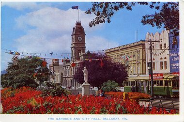 Ballarat Tramway Museum
Postcard, Rose Stereograph Co, "The Gardens and City Hall. Ballarat Vic.", mid 1960's
... Colour postcard print of the central median gardens, Sturt... Hall Gardens Sturt St Begonia Festival tram 11 tram 15 tram 30 ...Has a strong association with the Rose Stereograph Co, demonstrates the gardens displays in Ballarat c1960's and yields information about the streetscape at the time.Colour postcard print of the central median gardens, Sturt St, with the Town Hall in the background and bogie tram No. 37 on the South Side. Has festoon lighting and other street decorations (Begonia Festival?) in the view. In the background are Myers, the Town Hall and Fletcher Jones store. No. 37 has the destination of Sebastopol and a "Switch to Electric Cooking" roof advertisement. Title "The Gardens and City Hall. Ballarat Vic." Postcard - Rose Series Colorview No. 509. On rear is the rose of Rose Stereograph Co and information. Duplicate of Reg Item - 1025On reverse side - black ink stamp "E.G.Butland"trams, tramways, town hall, gardens, sturt st, begonia festival, tram 11, tram 15, tram 30, tram 302, tram 27, tram 28 -
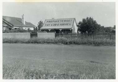 City of Moorabbin Historical Society (Operating the Box Cottage Museum)
Photograph, Black & White, J.Redmore "God Cottage' Bentleigh c1890, c1900
1890 - 1950 This little cottage was located near the corner of Centre Road and Jasper Road East Brighton ( now Bentleigh) between where the Bentleigh RSL and Woolworths Supermarket now stand. Rev.B.Redmore, and his wife, were early members of the Salvation Army Corps, and they went to unusual lengths to proclaim their faith. Texts were hung along the veranda to catch the attention of passers-by and on the iron roof was painted a large sign ' PREPARE TO MEET THY GOD O' ISRAEL' ( The apostrophe is not a misprint.) The Cottage became known locally as The "God Cottage" and was demolished c1950 ( H.Stanley 2005)The 'God Cottage ' with its Biblical texts and large roof sign was an unique feature in East Brighton ( Bentleigh) 1890 - 1950 Black & White photograph showing a small cottage with a large sign painted on the roofBack Handwritten informationredmore reverend b, salvation army, smith j l; smith mary ann, stanley helen, smith vic, chaff cutter, horse drawn carts, toll gates brighton, motor cars 1900, steam engines, early settlers, bentleigh, mckinnon, parish of moorabbin, city of moorabbin, county of bourke, moorabbin roads board, shire of moorabbin, henry dendy's special survey 1841, were j.b.; bent thomas, o'shannassy john, king richard, charman stephen, highett william, ormond francis, maynard dennis, market gardeners, vineyards, orchards -
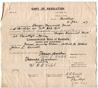 City of Moorabbin Historical Society (Operating the Box Cottage Museum)
Document - Fundraising for the 'Burgess Memorial Fund', c 1916-1917
At a public meeting in January 1917 the residents of the Shire of Moorabbin decided to appeal for funds for the purpose of erecting a memorial to the memory of the late Councillor William George Burgess, who died on 29 November 1916. The committee that was formed to oversee this project described Mr Burgess and his accomplishments: “Mr Burgess served the Shire of Moorabbin in the that capacity faithfully and will for upwards of 35 years. Mr Burgess was a resident of the shire since early boyhood and all through life either initiated or identified himself closely with every movement for the advancement of the district. The acquisition of the Bentleigh Reserve is evidence of his untiring energy and zeal, and it is now proposed to erect a brick pavilion thereon as a monument to the memory of one who had striven to leave the world, and the district in which he resided, a little better than he found it.” The “Burgess Memorial Pavilion” was opened on 13 October 1917. The pavilion was built of brick, with tiled roof, containing two rooms, one 12ft x17ft, the other 12ft x 9ft, a spacious verandah, supported by brick pillars was provided on two sides of the building. Unfortunately the Burgess Pavilion burnt down in June 1928. William Burgess was a Councillor for the Shire of Moorabbin for over 35 years, during which he was the President for five terms. William was a market gardener in Mackay Road, Bentleigh. His family settled in the district in 1855.Two paper documents: One a copy of a resolution re the opening of a bank account ; two a letter from the Southern Cross Press which accompanied a donation for the Burgess Memorial Fundwilliam burgess, the burgess pavilion, bentleigh recreational ground, fundraising, sport, shire of moorabbin -
 City of Moorabbin Historical Society (Operating the Box Cottage Museum)
Newsletter, City of Moorabbin Historical Society Feb 2009, February 2009
The City of Moorabbin Historical Society was formed c 1960 by a group of Moorabbin residents who were concerned that the history of the area should be preserved. A good response to a call for items related to the historical area of Moorabbin Shire brought donations of a wide variety of artefacts which are now preserved by the current members of CMHS at Box Cottage Museum . Helen Stanley, Secretary of CMHS, began producing a Newsletter for members in April 2007 to provide current information and well researched items of historical interest.Helen Stanley has produced a bi-monthly Newsletter, 2007 - 2013, for the members of the City of Moorabbin Historical Society that contains well researched interesting historical items, notification of upcoming events, current advice from Royal Australian Historical Society , Museums Australia Victoria and activities of Local Historical Societies. The Newsletter is an important record of the activities of the CMHS. Tom Sheehy, past President of CMHS, was an Historian and Author of ‘Battlers Tamed the Sandbelt’. 2 x A4 paper printed on 3 sides Issue 10 of the bi-monthly, City of Moorabbin Historical Society Newsletter produced by Society member and Secretary, Mrs Helen Stanley in February 2009. The Victorian Bushfire tragedy around Marysville is still unfolding as this Newsletter is written. The first meeting for the year is February 22nd and subscriptions are due. An excerpt is transcribed from the City of Moorabbin Historical Society Newsletter October 1962, “A Piece of History in Ormond” by an unknown eyewitness author, describing the original “Box Cottage” situated in Mr J. Reitman’s cement products factory at 306 Jasper Road, Ormond prior to demolition. The current Editor gives information obtained from further recent research . An Article by Tom Sheehy, past President and Historian, February 1979 “The Vineyards of Moorabbin”. The ‘Brighton Estate” began when Henry Moor brought Vine cuttings from Camden NSW 1848 and they were productive after 3 years. Many Vineyards then appeared from Port Phillip Bay to East Boundary Road and produced 2/3 of the annual Victorian grape crop. Disease or insect caused failure in1858 and the land reverted to market gardens. A coloured photocopied photo of Box Cottage 2005. CITY of MOORABBIN HISTORICAL SOCIETY / FEBRUARY 2009 NEWSLETTERcity of moorabbin historical society, stanley helen, sheehy tom, melbourne, moorabbin, brighton, cheltenham, ormond, bentleigh, vineyards, fruit growing, vine diseases, winemaking, grapes, market gardeners, pioneers, early settlers, moorabbin shire, box cottage museum, dairy, port phillip bay, brighton estate, moor henry, cambden estate, reitman j., reitman w., cement, pottery, jasper road ormond, east boundary road brighton, dendy’s special survey 1851, point nepean road, south road brighton, thomas street brighton, north road brighton, county of bourke, box h., box william, bruton william, brighton brewery, parish of moorabbin, parish of prahran, markets, shingle roof, weather-board, downward mr., mckinnon -
 City of Moorabbin Historical Society (Operating the Box Cottage Museum)
Newsletter, City of Moorabbin Historical Society Apr 2009, April 2009
The City of Moorabbin Historical Society was formed c 1960 by a group of Moorabbin residents who were concerned that the history of the area should be preserved. A good response to a call for items related to the historical area of Moorabbin Shire brought donations of a wide variety of artefacts which are now preserved by the current members of CMHS at Box Cottage Museum . Helen Stanley, Secretary of CMHS, began producing a Newsletter for members in April 2007 to provide current information and well researched items of historical interest.Helen Stanley has produced a bi-monthly Newsletter, 2007 - 2013, for the members of the City of Moorabbin Historical Society that contains well researched interesting historical items, notification of upcoming events, current advice from Royal Australian Historical Society , Museums Australia Victoria and activities of Local Historical Societies. The Newsletter is an important record of the activities of the CMHS.2 x A4 paper printed on 4 sides Issue 11 of the bi-monthly, City of Moorabbin Historical Society Newsletter produced by Society member and Secretary, Mrs Helen Stanley in April 2009. Notice that Mr Travis Sellars, Friends of Cheltenham and Regional Cemeteries, will talk about ‘The Tragic 20’s’ at the meeting April 26th . Volunteers are needed to show visitors around on Open Days each month and a Roster will be made on April 26th . Suggestions are requested for the Community Grant Application to be submitted by CMHS. Historical details are condensed from ‘ The Living Harvest’ by W.T Dobson, describing the establishment of St. Peter’s Catholic School East Bentleigh 1865 on land donated by Fred Quinn , in Centre Road, East Brighton ( East Bentleigh). A photo copy of Parts of Country Portion 39 of Dendy’s Special Survey or Brighton Estate showing the Land Sales of Lot 2, & 3 North Road and Jasper Road 1841 – 1869. Interesting note on the origin of ‘Jasper Road’. 3 photocopied photographs of St Peter’s School building 1903, School Children at East Brighton Railway Station, 1903, A Lorry in the parade 1903. CITY of MOORABBIN HISTORICAL SOCIETY / APRIL 2009 NEWSLETTERcity of moorabbin historical society, stanley helen, dobson w.t., melbourne, moorabbin, brighton, friends of cheltenham and reional cemeteries, cheltenham, ormond, bentleigh, market gardeners, irish immigrants c1850pioneers, early settlers, moorabbin shire, box cottage museum, port phillip bay, brighton estate, jasper road ormond, east boundary road brighton, dendy’s special survey 1851, point nepean road, south road brighton, thomas street brighton, north road brighton, county of bourke, box h., box william, parish of moorabbin, parish of prahran, markets, shingle roof, weather-board, mr., mckinnon, were jonathan, niall rev. fr. patrick, quinn fred, elsternwick, catholic church directory 1878, hibernian society melbourne, brady peter., kennedy mr., boland mr., leary mr., gahan mr., archbishop carr, rev. fr. gough., presentation convent gardenvale, sister mary vincent, charlston john, bavarian dress band, hales jasper -
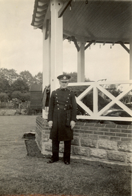 Federation University Historical Collection
Photograph - Black and White, Frank Wright standing in front of a bandstand at Staines, Middlesex, 22/5/1934
Frank Wright was a renown resident of Smeaton, where he was born on 2 August 1901. He lived at Laura Villa, and attended Smeaton State School. His father William was a gold miner and his mother's name was Sarah. Their family won many singing and instrumental awards. Frank was tutored by Percy Code and was awarded a gold medal for the highest marks in the ALCM examinations in the British Colonies at the age of seventeen years. He became the Australian Open Cornet Champion by the age of eighteen. A year later, Frank conducted the City of Ballarat Band, and later the Ballarat Soldiers’ Memorial Band. He formed the Frank Wright Frisco Band and Frank Wright and his Coliseum Orchestra. These bands won many South Street awards, and Frank as conductor won many awards in the Australian Band Championship contest. In 1933 Frank Wright sailed to England to conduct the famous St Hilda’s Band and was later appointed Musical Director of the London County Council, where he organized many amazing concerts in parks, in and around the London district. He was made Professor of Brass and Military Band Scoring and conducted at the Guildhall of Music and Drama. Frank was often invited to adjudicate Brass Band Championships around Europe, in Australia, including South Street and in New Zealand. The Frank Wright Medal at the Royal South Street competition is awarded to an individual recognized as making an outstanding contribution to brass music in Australia.Black and white photograph of a man dressed in a band uniform standing on the grass in front of a raised bandstand. The bandstand has a stone and brick base, a white railed balustrade, white timber support columns and a roof. In the back ground is a garden, timber building and trees. The man is Frank Wright and he is dressed is the St. Hilda's band uniform.Written in pencil on the back - Frank Wright 32, Conductor St Hilda's, Staines, 22/5/34frank wright, brass band, conductor, bandstand, staines -
 Ringwood and District Historical Society
Letter, Property for sale - Ringwood Shop and Dwelling Estate, Ringwood, Victoria - circa 1925
ID 5225 note: Further information relating to allotments marked on the hand-drawn plan are included in ID 5224 - Ringwood Station Estate.Typewritten letter from A.V. Greenwood with hand drawn plan of Ringwood Shop and Dwelling Estate, detailed description of property for sale, and top and side elevation views of house. (7 pages)(Transcript of first page - to unknown recipient) Phone 988 Central, 331 Canty Greenwood Pty. Ltd. 5 Flinders Street Melbourne. Dear Sir, 1. Attached please find drawings of my house at Ringwood. 2. It is for sale at £4,865 or to let at £5 per week to an approved tenant. 3. I sold it to Mr. De Garis and vacated it, but it is now back on my hands. 4. I leased another place instead of living in my own. I may be able to cancel same; in the meantime, however, I propose to sell or let my own. The painters are now going through the place; re-varnishing, re-oiling and re-polishing so that in about five days it will look "spick and span". 5. The house was specially built under my own supervision. 6. It is very suitable for a high class Guest House, Doctor's residence, Hospital or Convalescent Home. If you know of anyone whom it might suit, please communicate with them. DESCRIPTION 7. It stands on 305 feet of land facing Greenwood Avenue. It is cement, roughcast and hardwood, well oiled, and is now being redone so that the house is as good as new; red tile roof; verandahs three sides; two sleep-outs; five bedrooms; large dining room; very large music room with nooks, upstairs lounge, study; sewing room; built-in wardrobes and cupboards throughout; handsome kitchen with handsome pantry cupboard with drawers and glass front; one bath room; one shower room; wash house with patent copper and laundry. Every modern convenience, hot water system (through copper pipes with large copper cylinder) electric lights everywhere, outside and in, Yan Yean water laid on everwhere throughout house and gardens. Floors throughout are the very best, close set, stained and polished; dainty lead light windows etc. 8. There is a big garage, with tiled roof and two rooms with all conveniences for a married couple. Property is well drained with a system of its own. The house stands upon the top of a hill close to Railway Station, say 500 feet from the Footbridge. 9. The garden has expansive shrubs; sheds; fernery; tennis court. 10. A handsome piece of furniture goes with the house; a combination pantry and storeroom for groceries, milk, bread etc., consisting of drawers, glass and wire doors, as mentioned above. 11. It is within easy distance of Melbourne as it is only two minutes from Ringwood Station, which is a frequent electric train service bringing it within 39 minutes of the City. It is thought better by some to go further out into the country atmosphere and walk a short distance at the end than to go by train 20 minutes then walk 15 to 20 minutes. 12. The price quoted of £4,865 is made up as follows - 305 feet of land @ £5 ... £1,515 Garage and dwelling ... £300 House hot water system, American cupboard ... £2,600 Water, fencing, sheds & drain ... £250 For the lot ... £4,865 Should you require copies of the enclosed drawings I shall be pleased to supply same. 13. Mr. J.B. McAlpin is the local agent, Phone Ring. 7 (after hours Ring. 44) or you may phone me Central 988. 14. The house is south of the line, facing Greenwood Avenue and immediately at the back of Ringwood House, which is also my property. Yours sincerely, A.V. Greenwood (illegible) ..... (Transcript of second page) RINGWOOD SHOP AND DWELLING ESTATE See these letters on plan attached (H.) Ringwood House and Shops on 100 by 150 feet of land fronting Bedford Road 100 feet @ £10 per foot - £1,000 House and shops - £2,400 ... £3,400 Ringwood House consists of Boarding House, (Phone 101) and two shops, mainly brick; 9 inch walls. Will carry another story. Has music room, dining room, entrance halls, 10 bedrooms, large verandahs, all conveniences, hot and cold water, and stands on what will become a most valuable business corner. (F.)(G.) Mr. Greenwood's house, garage and sheds, stands on 307 feet of land fronting Greenwood Avenue. See detailed description attached ... £4,865 (J.) Cottage on Block 81 in William Street ... £750 (K.) Cottage in Pitt Street ... £650 (Total) £9,665 ..... (Description of third page - Subdivision Plan) Drawn by Edyth Greenwood, phone 988 Central. Subdivision includes Station Street, Pitt Street, Bedford Road, Wantirna Road, James Street, William Street (later Kendall Street), Greenwood Avenue, Ellison Street, and Haig Street. Circles denote blocks for sale. Squares denote house properties for sale. Other features marked include location of businesses along Main Street (Maroondah Highway), cool store, railway station, shop and police station on Bedford Road, church on Station Street, site of schoolmaster's residence and State School, and location of proposed public baths -
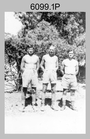 Bendigo Military Museum
photograph - Fortuna - 1st Year of Army Occupation in Bendigo, 1942
This is a set of 17 photographs taken during the first year of Army occupation at Fortuna, Bendigo in 1942. The photos provide an insight into the preparatory work performed on the Fortuna Villa and surrounding buildings, by the Working Party 5th Army Troop and Ordnance Training Depot, before its occupation by personnel from LHQ Cartographic Company, Royal Australian Survey Corps. The annotation on the back of Photos .9P and .10P is misspelt. The correct spelling is ‘Nell Gwynne’. The poppet head of the Central Nell Gwynne mine is still an iconic landmark in Bendigo, lying just down the road from the poppet head lookout at Victoria Hill. The Central Nell Gwynne was the premier mine of Bendigo's 1930s mining revival and is of high historical value, due to the extensive and relatively intact features which remain at the site. The annotation on the back of Photo .17P is incorrect. The location of HQ 5th Army Troop was ‘Reynard St, Coburg.’ By late 1941 as Japan extended its control throughout Indo-China, resolving the accommodation problem of AHQ Cartographic Company located in Melbourne became more urgent. The steady Japanese advance made the bombing of Melbourne no longer a remote possibility, and in accordance with a general policy of dispersion, the Deputy Chief of the General Staff, Major General Sidney Rowell instructed Major William Sarll, in the interests of security of plant and to provide against possible damage of air attack, to investigate suitable safer inland accommodation for AHQ Cartographic Company. Major Sarll inspected many properties before finding one that would meet the requirements of the Cartographic Company. In late 1941, he came to inspect Fortuna, a rambling old mansion with about fifteen acres of ground in central Bendigo. Initially there was no intention to occupy the site beyond the end of the war, although Major Sarll's report to the Director of Survey noted many advantages in moving the Company to Bendigo. Major General Rowell quickly approved the selection of Fortuna before other authorities, which were investigating the evacuation of school children, could get in ahead of the Cartographic Company. On 23 March 1942, the Commonwealth of Australia, under the provisions of the National Security Act of 1939, took possession of the house, the old battery buildings and the fifteen acres of grounds. Under Warrant Officer J. Trist’s direction, over fifty Parks and Works tradesmen completed building works necessary to accommodate the Survey Corps’ military, map making and printing requirements. The building program was still under way when the first officer, Lieutenant Ralph Westgarth, arrived in May 1942 with the advance party which received and positioned all equipment as it came up from Melbourne in semi-trailers. Once the equipment was installed the rest of the Cartographic Company completed its shift to Bendigo by 11th June 1942. The first year of the Survey Corps’ occupation of Fortuna is covered in more detail with additional historic photographs, in pages 17-22 of Valerie Lovejoy’s book 'Mapmakers of Fortuna – A history of the Army Survey Regiment’ ISBN: 0-646-42120-4.This is a set of 17 photographs taken during the first year of Army Occupation at Fortuna, Bendigo in 1942. The black and white photographs were printed on photographic paper and are part of the Army Survey Regiment’s Collection. The photographs were scanned at 300 dpi. .1) - Photo, black & white, 1942. Bendigo Parks and Works tradesmen at Fortuna. L to R: Cliff Day, Ernie Arnold, Norm? .2) - Photo, black & white, 1942. “Don” - possibly SGT Don Sutcliffe. Fortuna, Bendigo. .3) - Photo, black & white, 1942. Parks and Works tradesmen in garden at Fortuna, Bendigo. L to R: Fred & Ernie. .4) - Photo, black & white, 1942. Benny Jack Williams at Fortuna, Bendigo. Accommodation tents were erected above the lake, which later became the parade ground. .5) - Photo, black & white, 1942. Working dress - Giggle suits. Parks and Works tradesmen at Fortuna, Bendigo. L to R: Cliff and Harry on big roof. .6) - Photo, black & white, 1942. Parks and Works tradesmen at Fortuna, Bendigo. Ted on big roof. .7) - Photo, black & white, 1942. Gold crusher battery just behind Fortuna. .8) - Photo, black & white, 1942. Scene of Bendigo from Fortuna. .9) - Photo, black & white, 1942. Nell Gwynne Mine from mullock heap at Victoria Hill near Fortuna, Bendigo. .10) - Photo, black & white, 1942. Nell Gwynne Mine and crusher near Fortuna, Bendigo. .11) - Photo, black & white, 1942. Sluicing for gold at Eaglehawk. .12) - Photo, black & white, 1942. Fortuna, Bendigo taken from the far side of tennis courts. .13) - Photo, black & white, 1942. Fortuna, Bendigo & its reflection from across the lake. .14) - Photo, black & white, 1942. Fortuna, Bendigo from the fishpond. .15) - Photo, black & white, 1942. Fortuna, Bendigo. .16) - Photo, black & white, 1942. First Fortuna Football Team at unknown location. L to R: 5th Bob Wright, 11th SGT Don Sutcliffe. .17) - Photo, black & white, 1942. Working Party from 5th Army Troop and Ordnance Training Depot at Fortuna, Bendigo.Some personnel are identified. Annotated with date within photos. .1) – Annotated on back ‘Cliff, Ernie, Norm, Dec ‘42. Cliff Day - dairy farmer, plasterers’ labourer. Ernie Arnold – hard plasterer. Norm? - QM Store for tools etc. QM Store was the Stables.’ .2) - Annotated on back ‘Don. Fortuna 1942’ .3) - Annotated on back ‘Fred & Ernie. Dec 1942. Carpenters. Note the state of the gardens.’ .4) - Annotated on back ‘Benny Jack Williams Fortuna Bendigo. Tents were erected where present day parade ground is above the lake.’ .5) - Annotated on back ‘Working dress - Giggle suits. June 42. Cliff and Harry on big roof. This photo was taken as the ventilating ridge was being installed on the building housing the printing machines. The machines were installed later by civilian labour when building was complete.’ .6) - Annotated on back ‘Ted on big roof Fortuna Bendigo.’ .7) - Annotated on back ‘Gold crusher battery – Bendigo for slay heap – 1942. 12 stamp battery. Just behind Fortuna. Was working at night when the “Army” came to Bendigo. Later removed to “Coolgardie - WA. Present site of Southern Cross TV.’ .8) - Annotated on back ‘Scene of Bendigo from Fortuna. June 1942.’ .9) - Annotated on back ‘Nell Gwyne Mine from mullock heap (Victoria Hill) Sept 1942.’ .10) - Annotated on back ‘Nell Gwyne Mine and crusher September 1942.’ .11) - Annotated on back ‘Sluicing for gold at Eaglehawk. August 1942.’ .12) - Annotated on back ‘Fortuna Bendigo 1942. Taken from far side of tennis courts.’ .13) - Annotated on back ‘ “Fortuna” across the lake & reflection.’ .14) - Annotated on back ‘Fortuna from fishpond June 1942.’ .15) - Annotated on back ‘Fortuna Dec 1942.’ .16) - Annotated on front ‘X’ x2. Annotated on back First Fortuna Football Team 1942‘Bob Wright’, ‘SGT Don Sutcliffe’. .17) - Annotated ‘Working Party at Fortuna before one of the drafts’, Working Party 5th Army Troop and Ordnance Training Depot Showgrounds, now the Sportsground Bendigo’, ‘HQ of 5th Army Troop was Reynards Rd, Coburg.’royal australian survey corps, rasvy, army survey regiment, army svy regt, fortuna, asr -
 Orbost & District Historical Society
black and white photograph, late 19th century - early 20th century
This is a photograph of the home of Hamilton Reed who was an early settler at Goongerah. In 1868 Hamilton Reed and John Locke both of Bendoc secured a grazing area of 60,000 acres at Goongerah. About the year 1878 Hamilton Reed and C. W. Nicholson decided to, if possible, to go from Bendoc to Orbost via Goongerah, they accomplished the task in 4 days from Goongerah. (more info. Newsletter September 2004) Councillor Hamilton Rutherford Reed represented North Riding 1918 - 1936.This item is associated with Hamilton Reed an early settler of Goongerah who was a long -time member of Orbost Shire Council.A black / white photograph of a settler's wooden home surrounded by a garden. The house is made of upright slabs for the walls and has a stringy bark roof.reed-hamilton goongerah -
 Warrnambool and District Historical Society Inc.
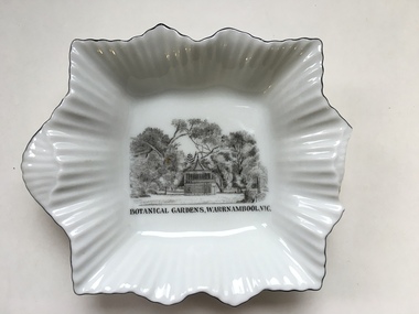
Dish, Warrnambool Botanic Gardens, C early to mid 20th century
The Rotunda in the Warrnambool Botanic gardens was constructed in 1913 at a cost of 297 pounds. It is situated toward the central eastern side of the gardens and is visible from many viewpoints in the gardens. The building is octagonal in shape with a steeply pitched tiled roof with the bandstand open area elevated to approximately 3 metres. The gardens designed by William Guilfoyle, commenced in 1866 have been a popular meeting place as well as entertainment and social community events. This dish would have been a souvenir or memento. A common souvenir type object .Small white china dish with square baseand fluted sides and lined edge.Transfer print of the rotunda at the Warrnambool Botanic gardens in black. fine black line around edge of dish.Botanic Gardens Warrnambool in black text below print on front of dish, made in Cechoslov 12 below crown with RKG inside the crown.warrnambool, warrnambool gardens rotunda, warrnambool botanic gardens -
 Eltham District Historical Society Inc
Photograph, Woodburn residence, mudbrick adobe (1949), Eltham Heritage Tour, 24 May 1992, 24/05/1992
ELTHAM HERITAGE TOUR The Society excursion on 24th May 1992 was arranged by David Bick, leader of the team carrying out the Shire's heritage study. David selected a number of sites or buildings identified in the study, some of them lesser known components of the Shire's heritage. The tour commenced at the Eltham Shire Office at 10.00 am. Travel was by private car and mini-bus with stops at about twelve locations for commentary by David.It included a short walk in Hurstbridge and lunch at Kinglake. Highlights of the tour included: - 10 am Leave from Shire Offices - 3 Important Trees - A Physical Link to Eltham's First Settlers - Toorak Mansion Gates - A Surviving Farm House - An Intact Circa 1900 Main Street - First Settlers - Gold Miners, and Timber-getters - An Early Hotel - A Pioneering Homestead - Changing Eltham Shire - 20th Century - 4 pm Afternoon Tea and Finish Tour Extract from ELTHAM CULTURAL HERITAGE TOUR (Newsletter No. 85, July 1992, by Bettina Woodburn) "In some respects Eltham is a 'back-water' and it has its own distinctive flavour. On the outskirts the homes date from the 1960's, 70's and 80s with a sprinkling of 'earth homes', mud-brick or pise, rammed dirt. Crossing Main Road into Beddoe Street and Thompson Crescent a very pleasant drive past pines and old fence lines, front lawns unfenced, the occasional ·old farm building, we eventually looked down on a huge circular roof of a 1992 adobe home. Other distinctive places included the Pauline Toner Butterfly Reserve, Gordon Ford's splendid garden at Fulling in Pitt Street, cypress hedges and old houses in Bridge Street and in every direction Eltham's special feature - a totally treed horizon. We were now in the part of the Shire closest to Melbourne - Montmorency - not on the way to anywhere, with no through road going across it, developed in the 1950's and 1960's with conventional gardens, now converted to native plants. The rail looped between Greensborough and Eltham and a shopping street (Were Street) served the area, growing up the hill from the station. It was a typical outer Melbourne suburb with lawns and roses with patches of originality. The shopping precinct still has 1950 characteristics - walls which sloped back, projecting roofs, the original shop fronts are nearly all tiled below the old windows. There's an air of past times about the School, the Dairy, the Butcher's (now a milk bar) and the Castlemaine stone face of the Commonwealth Bank. The final stop for the tour was at the mud-brick Woodburn residence, adobe of 1949 with additions. After War Service, Bill Woodburn had commenced an Architecture course at Melbourne University and after second year in the Christmas vacation, with his wife, Betti, built the two bedroom house - with amazing saving of costs. In the three and a half months they made over 3000 bricks (external walls 18" x 12" x 4", internal walls 12" x 9" x 4"), sifted top soil for mortar and laid them, on concrete foundations and slab floor, made all the structural window frames, door frames and roof members to carry 'super six' asbestos sheets, laboured for the electrician and plumber, did all the glazing and, still without electricity, moved in in March 1949. Rooms have been added, at first with glass walls, later using concrete blocks, to accommodate three daughters and a son. The house not only grew from the earth, but also with the family."Record of the Society's history and activities and highlighting various aspects of the Heritage Study undertaken by David Bick used to create the future heritage overlay for the Shire of Eltham and later Nillumbik Shire.Roll of 35mm colour negative film, 4 stripsKodak Gold 100 5095shire of eltham historical society, activities, heritage tour, woodburn house -
 Port of Echuca
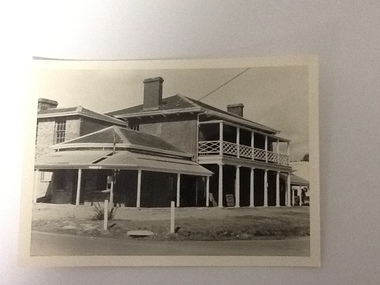
Black and white photograph, 20.04.1979
Relates to a series of 5 photos:P000094-P000098 of the front of the Bridge Hotel on the corner of Murray esplanade and Hopwood gardens. These photos taken in 1976, were before the Port Restoration Scheme renovated the hotel.The Bridge Hotel, Echuca is of historical and social significance in that it was originally built by Henry Hopwood, the founder of Echuca. Hopwood built the hotel to provide accommodation to people using his punts across the Campaspe and Murray rivers. The hotel was situated between the 2 punts. The hotel provided for a variety of levels of accommodation from grand rooms to very basic rooms. At the time of the photos the hotel was 120 years old and became an important part of the Port of Echuca tourism. Black and white photograph of the Bridge Hotel , taken from the corner of Murray esplanade and Hopwood gardens. A power pole pokes through the verandah roof of the eastern (left) wing. The eastern wing of the Bridge is clearly visible.On sign on the front verandah "unauthorised entry not permitted". On back of photo in pen :" 1"bridge hotel, echcua, port restoration scheme, bridge hotel restoration, echuca -
University of Melbourne, Burnley Campus Archives
Plan - Photocopy, New Cottage for Caretaker Royal Horticultural Gardens Burnley 1897, 1897
Photocopies. New cottage for Caretaker, Royal Horticultural Gardens Burnley (1) Elevations, Ground floor and Roof plans. Drawing No 1 dated 5th March 1897 GB 5198. (2) Detail Drawings. Drawing No 2. From Public Records Office.Signed SEM (?) 5-1-97; J. Fisher, F.J. Moore (?) 5 Mar. 97caretaker's cottage, burnley gardens -
University of Melbourne, Burnley Campus Archives
Plan - Photocopy, Additions to Curator's Residence Royal Horticultural Gardens Burnley 1899, 1899
Photocopy. Additions to Curator's Residence, Royal Horticultural Gardens, Burnley. Elevations and Ground and Roof Plan. Drawing No 1 Stamped GB 5169. Dated 6.6.99. From Public Records Office.burnley gardens, curator's residence -
University of Melbourne, Burnley Campus Archives
Plan, New School of Primary Agriculture & Horticulture Burnley Gardens, 1945
Photocopy of Plan of the Administration Building by the Chief Architect dated 26.9.45. Scale 1/8 inch - 1 foot. Photocopy reduced in size from original. (1) Ground Floor and First Floor Plans. (2) West Elevation, Longitudinal Section 'B-B' and East Front Elevation. (3) Flat Roof, Library and Herbarium. (4) Common Room and Assembly Hall. Originally in the Burnley Archives. Property and Service now have the original and gave the reduced size photocopy to the Archives. Hard to read now.burnley gardens, school of primary agriculture and horticulture